Palyoplot 0.0.17 Available

This update fixes the plotting that was broken with the massive ggplot2 3.5.0 updates/improvements. Does not use their improvements beyond just getting the code to work again. Have a known issue where y.break may not be honored as expected in palyoplot_plotData (it might round differently if R thinkings it’s cleaner. Working on it but wanted to get this out). A minor bug fix to palyoplot_plotIndex(), made the tutorial pages on the website formatted consistently, and updated syntax on tutorials to match the latest code version. File to install is at: http://geotechnography.com/samples/palyoplot.palyoplot_0.0.17.tar.gz.

A round of testing and Palyoplot should be Beta. Feedback as always is appreciated. See Palyoplot: R Package in the top-right header for graphical guided tutorials using both built-in and dummy datasets.

History of versions, changelog, and a sample R files are available at: http://geotechnography.com/samples/palyoplot/
Overlaying index plots now available in Palyoplot

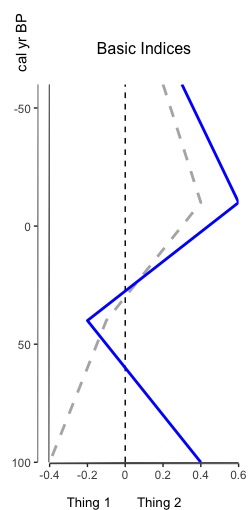
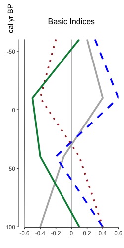
That’s right, you heard me. You can now overlay multiple indices on one plot. Why? Because sometimes appending graphs just isn’t good enough and you really need to overlay two index datasets (or more) to see that relationship between them. The tutorial for how to do so is now available, and it leverages all the same styling options as plotting an index. Here’s a sneak peak of two different overlaid plots: one reasonable one with two datasets, and another to show that you can put multiple one one graph. I don’t know why you’d want to do that, but I figured “hey, why not”.

Overlaid Indices (2 indices)
Fig 1. Basic sample of two overlaid indices with dashed zero line
Multiple overlaid indices
Fig 2. Multiple overlaid indices with solid zeroline

Palyoplot 0.0.16 now available

A few bug fixes, Help file updates, and a new feature — plotting multiple indices on one graph (palyoplot_plotOverlaidIndices()) — tutorial coming soon. File to install is at: http://geotechnography.com/samples/palyoplot.palyoplot_0.0.16.tar.gz.

A round of testing and Palyoplot should be Beta. Feedback as always is appreciated. History of versions, changelog, and a revised sample R file are available at: http://geotechnography.com/samples/palyoplot/

Technology in the Field: Smartphones, Addendum 1

In the previous post I talked about having a smartphone in the field, and how I had not yet tested the waterproofness of the Samsung Galaxy S5. Welp, I accidentally tested it two weeks ago while out in the field on another coring trip. This time in a lake.

It was my very first lake coring trip, so I was excited to observe how the raft was anchored, positioned, and moved. In my excitement, I forgot that I had my phone in my pocket (as I usually do). Walking along the edge of the lake to position the first anchor point, the bottom suddenly disappeared and I found myself in knee-deep mud and waist-deep water. After fits of laughter and finally getting myself dislodged I remembered my phone (okay, more like 10 minutes later). “Oh no!” was my first thought. “Oh, wait…” was my second. Sure enough, phone coated in mud, wiped off, and still ticking. Yay for field photography when no one else is willing to get their real cameras (or phones) wet!

Continue reading “Technology in the Field: Smartphones, Addendum 1”

Technology in the Field: Smartphones

Once upon a time (back in 2011) I wrote an article on the accuracy of smartphones in the field compared to dedicated GPS units (click here to read it). Coming back from the field has reminded me that nothing’s changed — I’d still rather use my phone than wait for the GPS unit to power up and figure out where I am.

There’s plenty more GPS apps for smartphones now than there was 5 years ago, but I still find myself consistently going back to Maverick (Play Store). It’s simple, lets me drop my waypoint, take a georeferenced picture, add in descriptions, and makes me happy. Used to use OruxMap (Play Store). It has great features, but for some reason I just click on Maverick for fast fieldwork.

It’s nice to see people getting on board with smartphones as GPS, from geography field trips (article) to research investigations (article). Not nearly the backlash when I presented at conferences oh so many years ago (*gasp*! How DARE you say some PHONE is as good as a $2000 Trimble?!??).

Continue reading “Technology in the Field: Smartphones”